
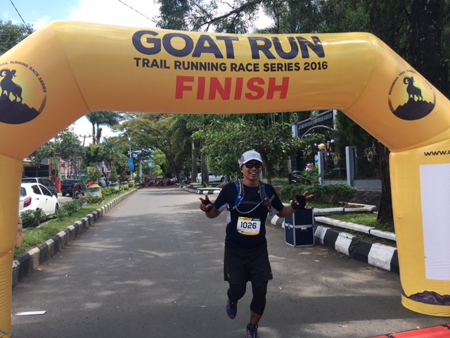
Until last year, I always scrambled for answers whenever someone asked for my recommendations on trail running races in Indonesia. Tahura is a good trail race in Bandung in January, with good organizer and beautiful route, but somehow it is not “Wow” enough for anyone to make an overseas trip to join.
This year, everyone was looking forward to the new Goat Run Race Series, which started with the Guntur Race last Sunday, March 27th. I am happy to report that it has exceeded my expectation. Finally, there is a destination trail race that is worth to recommend in Indonesia that is not only unique and challenging (yet still fun!) but also very well organized up to international standard.
Quick Summary
This is part of the 4 Goat Run Race Series where participants accumulate points from finishing and placing in top 40 of each race. At the end of the year the top male and female will be crowned as the Goat King and Queen and awarded free trips to join an international trail race event.
Finishers: 161 (58%) finished within Cut-Off-Time of 8 hours out of 277 registrants and around 240 starters

Would I recommend this race?
Definitely!! Granted, it is brutal and difficult (not few participants said that this was the most difficult race that they have ever done) but the challenges worthed the sweat. The course is really unique with breathtaking sceneries. You will get to experience changing terrains from village roads to forrested area to volcanic rocks to dirt road while surrounded by beautiful mountains. Markings were excellent, almost zero chance to get lost (Race director: “if you don’t see any marking for the last 30m – that means you are lost”). Water station was at every 5km, some with water only and some with electrolyte drinks, milo, fruits, and ice. Kuddos to the organizers who have set the standards on how a trail race should be set-up in Indonesia. So far they have been very responsive, informative, and open to any inputs and questions.
The Long Story
Preparations
– Long trail runs or a back-to-back long runs on weekend
The Fun Part – Gears
Even though it is only a 25km race, the technicality of the race required us to prepare a bit more. The big question before the race was: WITH or WITHOUT POLES. At the end, I decided with no poles, as I thought they would be useful for around 20% of the course and would be a nuisance for the rest. I was happy with my decision.
The other notable item that you may consider to bring are gaiters. The ones I wore were courtesy of Eric. Did not realize how useful they were but the fact that Eric had to take out and clean his shoes off small rocks at least 10 times because he lent me these while I did not at all, said a lot about the importance.
This is also the first race where I wore Altra LonePeak and I was so happy with them. I found these original version 1.0 in Singapore and aside from the really nice bright colors, they are also very comfortable, giving enough grip, light and nimble enough for most terrains. Very foot-friendly pair of shoes. “Once you’ve gone Altra, it is hard to go back” – quoting the owner of the Singapore’s specialty running store. The zero-drop was a killer if you are not used to them while climbing the steep climbs, but I swear that these pairs helped me to work on my glut.

My gears and clothing – the vest is courtesy of Angga
I really loaded myself on nutrition during this race. I carried 10 gels (and finished 9 of them), a pack of Japanese salt tablets, and 2 Vespa Amino Acid Supplements. The amino acid supplement supposed to reduce our lactate and stabilize glucose level thus reducing fatique and prevent cramps on muscles. I was not sure how much of that was true but I felt my leg muscles were “energized” after I took one sachet of it during the first km of the climb. People were passing me at the start of the climb but I managed to overtake many people during the last half of the climb after taking the supplement, coincidence??

Crazy loads of gels for a 25km race
The crew
This was a really fun race since many of my friends joined. The JFS (Jakarta Free Spirit) were well represented as this was supposed to be Andy’s “last” race in Indonesia before he heads back to the UK. Andy joined with his daughter Katie and her partner Steve, and the rest of the gang: Dean, Paul, Moray, Eric, Alex and Ninik. Although I have been regularly running with Eric since last October, this is the first race that we actually attended together. And I am really glad we did. Christovik also travelled back from Manila to do this race, and Anna finally conquered another Indonesian mountain than Mount Salak with this race. Well done Anna and I’m looking forward to your travel guide on Salak! Freddy also managed to squeeze his time to run this race despite his super hectic schedule. Good to run again with you Freddy!
Before the race
We were well prepared with the accommodation, largely thanks to Christovik, so we were staying just minutes away from the start/finish line. Four of us, Eric, Chris, Anna, and I decided to travel early on Friday morning. On the way there, we spotted Alex and Ninik’s car, so we bee-lined all the way to the hotel. The traffic was really bad that it took us a total of 8 hours to get to our hotel.

But we had some beautiful scenery along the way. Photo credit: Eric Chooi

And nice lunch with great company, along with Eric’s “touching” story with a boy. Photo credit: Anna Cottrell
Checked in, we found our favorite hang-out spot for the rest of the weekend at the Chocolate Cafe next door. The rest of the day was basically REST.

The next day, we started the day with a short run along the start of the race route towards the G mountain. Photo credit: Eric Chooi

…and hey, while sporting our Altras ….

….it is quite a cloudy day
During the race-pack collection, the boys and girls with no medical letters needed to do the check up, and we learned a few new things about ourselves.

Well…that is because I just had a nice farewell dinner….
 Getting my medical certificate signed. Photo credit: Andy Roby

After one, two, three more meals, we finally attended the race briefing in the evening….Photo credit: Goat Run
The Race Day
The first surprise we had in the morning of the race was how sunny it was. Looked like the pawang (rain’s shaman) worked his magic. Which meant it was going to be scorching hot if we run after 10am. Second surprise for me was Eric’s decision to run with me. I knew that he said so before but was not really sure that he meant it until the start line. By then, I was not very sure what it would mean to have him pacing me but sharing the experience of climbing Guntur together for the first time sounded like a really nice idea.

Before the race started with Christovik, Eric, and Freddy. Photo credit: Eric Chooi

With the Garut’s mayor – errr… the photographer personally handpicked the 3 of us. Photo credit: Goat Run
First 2-3km of the race was a gentle slope on tarmac road before we turned right toward villages’ dirt road. The road then turned to a combination of dirt road and volcanic rocks, all with soft runnable slope until km 7, when the big climb would start.
All the while, Eric did not say anything while I was remembering what he said, which was we should be really fresh when we hit the big climb. That would only mean that we should run the first 7km at easy pace, right?

Lovely view at the start of the race. Photo credit: Freddy Lee
At around km 3-4, we were starting to pass the 10km runners. This was an enjoyable run with views of mountains, paddyfields, and villages surrounding us. I felt pretty good too although I was starting to breathe heavier and kept thinking I needed to slow down, still anxious with the brutality of the climb we would face soon. Dean went ahead of us and at around km 5 and 6, Paul and Moray greeted and passed us as well. They were all better runners than me, so I did expect that to happen. From the beginning, Chris, Ninik, Katie, and Steve had all run much ahead of us. The only person that I expected to pass me but had not yet was Andy. He did have problems with his stomach until the day before.
The BIG Climb
It just started like that…..without much warnings….the road suddenly turned to a forrested walk and we started climbing up the path sometimes needing to use our hands to push up. My legs were not feeling well…or that was just in my head.
“Okay, I guess it is just me then…”
Around 3-4 runners passing us while I scrambled my way through the first part of the climb. Eric kept babbling about a lot of things which I could not remember what. I was trying to listen and answer him but most of the time I only managed a “yes” and a “huh”. Then we spotted Moray, looking cozy at one of the turns.
“Fixing my hair – this is tough ey”
We passed him but not long after, he passed us again. Then the walk turned into an open field where we could spot some tents on what looked like a camping area. Behind it raised the majestic Guntur peaks with a line of runners climbing up the path looking like colorful dots. It looked just brutal. The most brutal part was the fact that we could see the pain ahead as the climb was very exposed.
“You’re looking good, you’re looking very good. You’re doing well”
All the while Eric was cheering me up while taking photos, videos, and giving live updates to our friends. He did not look tired at all. I was all sweats already and he looked very fresh and dry. I decided to shut my mind and not listen to whatever he said.

Eric was doing live updates while I was focusing my next step. Photo credit: Goat Run
We started to pass people during the second part of the climb. I felt I was going really slow, focusing one step at a time, making sure I kept moving. The terrain was mostly loose small rocks where we had to be very careful with our footings. One wrong step and we would slide down. Not the most fun, but good training nevertheless. Half-way, we saw Moray sitting under a shady tree, looking like he was ready to camp.
“Giving live-updates now. This is tough”
He seemed to have a knack on picking cozy places to rest during the race. We laughed and continued on. Not long after we saw one of my favorite runners, Roy, just a few metres above us.
“First time I am using them, a bit awkward”
I could not believe we passed him, he is such a better runner than me. Then suddenly Eric looked enthusiastic and mischievious at the same time, basically giving the Eric’s look.
“Hmmm….”
She seemed to be moving faster after seeing us (or that was just my feelings) but we did pass her not long after. And finally we reached the peak. Wohoo

Trying to run to look good passing the second Water Station. Photo credit: Goat Run

…definitely a failed attempt for me while Eric made it look so easy. Photo credit: Goat Run #keepitreal
WS2 to WS3
After the WS2, there was stil another hundred metres to climb before the downhill. We bumped into Dean and started to run together again. Then the path turned into a steep downhill where I was struggling for some good minutes and being passed by at least 3 runners including Dean.

Looking down from the peak, Dean and myself in the picture. Photo credit: Eric Chooi

“Quick feet, Cheryl! The worst can happen is falling on your butt” – I still have got a lot to learn on downhill running. Photo credit: Eric Chooi
Finally managed to pick-up a bit of speed while running downhill, we reached the flatter part of the route. This was the most beautiful part of the race to me. Eric let me run in front of him and I felt like running above the clouds. The course was meandering through villagers’ field with mist and clouds surrounding us.
Km 11 to Water Station 3 which is around km 16 was really runnable for us. We passed a few more runners again including Dean who was having problems with his feet and certainly caught up with a few more at the water station.

Arriving at WS 3, energized with the nice route we just passed.

Quickly refuelling ourselves
WS3 to Finish
I knew there is yet another hill to climb before the finish line and it happened just after Water Station 3. The path to Gunung Putri’s peak was narrow and steep, while still a bit shady with vegetations, the heat was already attacking us. Eric was trying hard, pushing and pulling me at some bits, I thought that was hilarious, but I did not have the energy to laugh at the time. It was not a very long climb though, I guess after the first one, this second one felt like a tiny bump.
We collected our bracelet at the peak and I was glad that the route was going to be all downhill after. The downhill was challenging though. The organizer provided some ropes along to guide us down. And there were many tree roots which could easily caught our feet.
“Hmm…okay”
The last 5km on the village road and tarmac road felt really long. The heat was just on us. We did pass Paul around 3km before the finish line, he was dehydrated and did not have enough trainings for this race. 2km before the finish line, my feet was feeling hot and burning, so I was about to ask Eric if we could stop for a few seconds as I was sure noone else would catch us at the point.
“NO! It is only 2 more km!”
I guess he knew what I was about to ask. So with no more excuses, I tried to grasp what some elites said about running with your heart for the last 2km. I felt there were so many turns before reaching the finish but after the last turn, I saw the line with Jeffri, the race director, smiling, cheering and clapping for me, with that I actually managed to sprint and cross the finish line. Feeling dead-tired, taking out my crumpled bib from my pocket to receive my finisher’s medal, I heard someone announcing I was the third female to finish. Eric was all smile and gave me a big hug. I was so happy that Jeffri made the effort to wait and cheer for the finishers, a nice personal touch.

Open Female Podium – all JFS runners. Photo credit: Eric Chooi
We completed the race in 5:02 hours, a fantastic time for me, and obviously a walk-in-park for Eric. I found out that Katie finished more than an hour earlier becoming the 6th finisher and first female overall. She kicked ass and earn the right to brag about kicking so many guys’ asses but still so humble about it. And Ninik finished around 20 minutes ahead of me. Chris was ten minutes ahead of Ninik. Steve, dehydrated towards the end of the race, finished ten minutes before me. So overall, JFS took all the top3 female finishers. An amazing feat.
Paul, Dean, Moray, and Andy crossed the finish line not long after, all under 6 hours. Then Anna at around 6:30 hours, Alex not long after Anna and Freddy at 7 hours.
 JFS after the finish, Steve, Katie, Moray, Dean, Paul, and Andy. Photo credit: Yani Saloh

Anna getting her medal
Freddy crossing the finish line
The aftermath
We had a nice break at Padma Bandung before heading back to Jakarta on Monday. Eric carried all sorts of foam rollers that you can imagine so we spent a lot of time stretching and rolling our sore quads and calves. Thanks to that, I managed to go back to my regular training just a few days after. Some sore quad muscles (embrace the DOMS!) but no particular complaints.
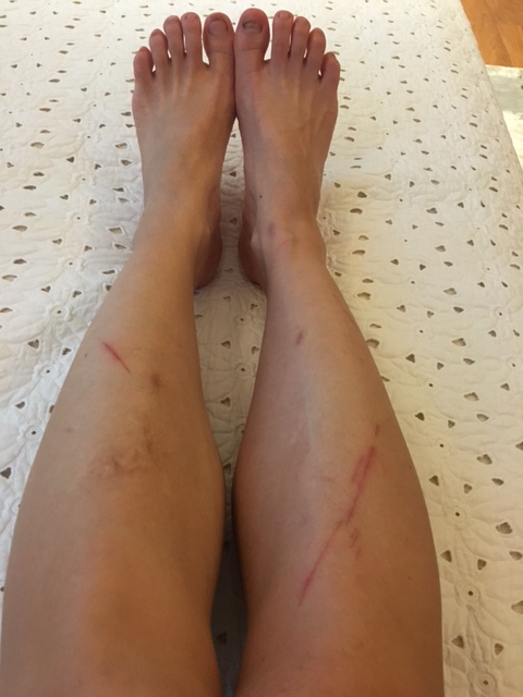
Uglier the feet and legs, tighter the ass…..

Race Report – Bromo Tengger Semeru Ultra 2015 (BTS Ultra)- 70km Distance
After enjoying my first experience of an “ultra” race in Mongolia, I felt a bit more confident to up my distance in running. Thus, I signed up for a 70km distance on a local race in East Java, Indonesia which was held in early November 2015. Bromo Tengger Semeru Ultra (or more well known as BTS ultra – or also nicknamed as “Brutal Torturous Sadistic” race) was first held in 2013. It is one of the most scenic race in Indonesia as the route crosses several mountain ranges, from Mount Bromo to Mount Semeru, and to Mount Batok for the longer distances. It offers several distances: 10km, 30km, 70km, 102km, and 170km.
The 170km is quite notorious as the finishers’ rate is generally low, ranging around 20-45% finishers out of the number people who started. I chose the 70km as it seemed to have a “reasonable” altitude gain of 2,950m for the distance and it is supposed to be very scenic, passing the scenic highlights of both Mount Bromo and Mount Semeru area.
For further information on the race, you can visit its website at: http://www.bromotenggersemeru100ultra.com/
First, Training
Hmmm, how did I prepare differently for this race than others? Prior to BTS’ training, my weekly milleages was around 40km, which consists of:
– Two weekday runs of 8km
– 7-10km run on Saturday if I do run on this day
– 15-20km run on Sunday
I felt that I should be okay to finish the 70km race if I keep this milleage and do a few modifications to my trainings:
– Do at least one trail run per week
– Increase my long runs up-to 30km per run
– Do a few back-to-back long runs to train running on tired legs (Also I figured I would not have the chance to run a 40-50km run at one go)
– Hills training once a week which for convenience sake I only did at home (up and down the stairs) or on treadmills for around 45-60 mins per session
Unfortunately, the haze condition affecting Singapore a few weeks prior to the race affected my training plan. As I could not run outside when it was hazy. And I could not run more than 10km on treadmills as it is extremely boring.
Luckily, I made a very good decision by making an impromptu travel to Copenhagen and Norway in early October. During that trip, I managed to catch up on my long run training. I think the average weekly milleage I did during the trip was around 80km. The cold weather was just a nice addition. That provided a good chance for me to test which gears would be most comfortable to wear during the cold mountain night in Bromo when the race started.
Second, Gear Selection
Part of the fun of running is the gears, well, at least for most of us. I do think most of the gears we use were not only essentials but also make us look pretty cool. So, here were my selections for the race:
Clothings and Shoes:
While I generally prefer neutral or light colors for my everyday clothes, I always choose really bright colors for my outdoor gears. I want to be seen in the mountains if I ever get lost, by a goat at least.
– Icebreaker merino panty – comfortable and antibacterial which keeps any odors away
– Lululemon run-for-days bra – comfortable, stylish and also antibacterial….can you guess what I’m trying to avoid here?
– Icebreaker light longsleeve tee – I learned from my trip in Norway that merino top works best for me when running in cold weather. I chose the lightest version from Icebreaker as it gets pretty warm when the sun was up
– 2XU compression pants
– Injinji trail running socks – I wore double layers on my right foot as it is 1.5cm shorter than my left
– A buff headwear worn around the neck – on hindsight, I think I should have packed another one since this got extremely dirty in the middle of the race. A fresh one will be helpful to wipe dirt off my face
– Asics running cap
– Salomon Speed Cross 3 – this was a last minute change from my previous plan of wearing my Altra Superior, which I love but I still found them difficult to run with on sandy ground. As most of the trail will be sandy, I feel the Salomon pairs give me the easiest lift off the ground. Another upside was its very tight weaving on its upper mesh helped to prevent more sands from getting into the shoes.
Due to my shoes selection as well, I decided not to wear any gaiters as I found them too complicated and I did not have the chance to try them out either

Gears:
– Salomon S-Lab ADV Skin3 12L – a good and very light vest with huge capacity and thoughtful design as we don’t need to take it off getting into anything. However, I was having problems with its fit. I already wore the smallest size of XXS and adjusted it to the tightest possible but I still had some chaffing problems which was not fun
– 3 x 500ml Salomon soft flask – I brought 1 extra bottle and kept it full during later part of the race when the sun came up to make sure I have enough hydration throughout.
– Black Diamond ultra distance carbon z-poles – very handy in the last 10km in the sandy area
– Silva Ninox II headlamp (140 lumens) – Personally I think this was not bright enough for the race (note: I did not bother to change the battery after 4 hours)
– Garmin Fenix 3 watch
Nutrition and others:
I feel this is one of the most important part of the race preparation
– 18 x Gu Gels Salted watermelon and salted caramel flavor – love the salted flavors! I took one gel every 45 minutes
– 4 x Tailwind Stick (each has 200 calories to be mixed into water as additional nutrition)
– One pack of Japanese salt tablets – I think anyone should stock up on these whenever they visit Japan
– Avene Spray to clean my face and hands prior to applying sunblock
– Dermatone Sunscreen lotion SPF 36 – starting at sunrise I applied and reapplied sunblock at every water station just because……
– One pack of first aid kit
– Additional preparation to prevent blisters: I applied Compeed blister prevention patches on my foot areas that are proned to blisters, e.g. the side of both toes just before the race (Compeed is a hydrocolloid patch that absorbs moisture and forms a protective cushion to prevent blister and help to heal blister faster if you already have one). I think if I had not done this, I would have blisters but I survived the race without any.

Before The Race
One great thing about a trail race is the people. For this BTS race in particular, I was very excited because my two good friends were joining. Sara, one of my best friends from school who was the first person who encouraged me to run. And Jia, a super sweet and laidback gal from Singapore who is always up for an adventure.
In addition to those two, we also picked up a young aspiring runner, Angga, to join our van from Surabaya airport. We got lots of tips from Angga’s “master”, on the strategy for the race. Basically he said: start slow, be very discipline on your nutrition, go fast on downhills.
We arrived on the morning of the race day (the race started at 23:30pm for the 70km distance). So after a 3-hour drive from the airport, we quickly made ourselves comfortable and just stuffed ourselves with whatever food we can find, while waiting for the race briefing.
The big news before the race start was the change of route due to the forest fire that was still affecting parts of Mount Semeru area. Instead of one big loop, we would run 2 loops around Mount Bromo before crossing the ocean of sand towards Bromo crater. The overall distance was also reduced from 70km to around 66km. The altitude gain was also reduced from 2,950m to around 2,400m.
I was honestly a bit discouraged with the news. Running two loops would be a mental challenge. The worst part of it was the fact that I would not be able to enjoy sunrise at Ranu Kumbolo in Mount Semeru area. But we were all there and we did our trainings, so no reasons to back-up. We all just went to bed at around 4pm to make sure we would get enough rest for the race.

At the start line with Jia and Sara
Finally, The Race
To avoid super long write-ups, I will divide the race into a few sections:
The first 6 km in the dark leading up to B29
I do not remember much about the first 6km of the race as I was just following the crowds and trying to stay together with Sara. We did not push hard at all and reminded each other to take our nutrition. I remember trying to use my poles during this part but felt they were not helpful and decided to put them back. The course was mostly soft downhills on sandy and grassy grounds. I felt a bit scared at times as I could not see whether we were by a cliff or something so I just basically kept on moving.
I spent approximately one hour for this part.
B29 hill, the first water station, and a nice long downhills to our second WS at Jemplang

The queue for B29 hike
You know you are at B29 when you see the long line of people in front of you looking like a big snake. Don’t look up just keep on moving. It is a 600m climb over 2km so it is quite steep but not too difficult. The course is mostly rocky and you can easily use your hands to scramble at some parts. We spent another one hour going up this hill.
The sight of the light from the first WS towards the end of B29 was a relief. Both Sara and I did not spend much time here, just quickly refilled our two soft flasks, and headed off again.
At this time, we were quite at the back of the race. The next 4km after was a soft uphill on sandy uneven ground. I did not particularly enjoy this part as the uneven ground made it very easy for us to twist our ankles. And in the dark through the light of our headlamp, we could see how much of this fine sand must have gone into our lung. Note for our future health.
During this part, I somehow lost Sara but I also managed to pass many runners, at least 20-30 of them. I felt quite energetic and tried to maintain my good momentum by not pushing hard. Then I bumped into my roommate for the race, Madam Lily, who was joining the 102km distance. So I ran with her for another 5km on sandy downhill course. After km 16, we hit a tarmac road, which was a good change for a speedier downhill then I lost Madam Lily, passed another 20 something runners and caught the sight of Jemplang water station, filled up my flasks and just headed off. I was still trying to find Sara here but could not locate her.
I think I spent around 2 hours 15 mins after B29 to Jemplang.
The Savanah and Back to B29 again
After Jemplang,the next 10km was a short downhill and a long stretch on a dark savannah. This was my loneliest and coldest part of the race. My headlight was starting to dim and I did not bother to change the battery. I did not come across anyone I know during this part and for most part I ran on my own in the dark cold savannah…(hahaha I know I am being dramatic but that was how I felt). This is also when I started to feel burning sensation on my urinary tract (not sure if it was real or just in my head) so I did stop a few times to do no. 1, luckily it was dark and I was completely by myself that I could just stop by the side of the track.
Then I started to see some runners coming by and starting to chat one of them. Just because I felt so lonely. He was an Indonesian guy working in Malaysia. And I was really thankful that I found him that I had a company to push me climbing through another round of B29, which was suddenly right in front of us.
So that was another 1 hour and 40mins for the part

View of the savannah in the light
Second B29, Sunrise and the second loop to Ranu Pane
Surprisingly, the second B29 climb was not too difficult, my newfound partner was very supportive and we could see the sun started to rise in the distance. And what a beautiful sight!

Sunrise at the distance
We spent around 50minutes climbing the B29 but then I spent around 10 minutes at the top to put on my sunscreen and reorganize my pack. This is when I met some fellow runners from Bandrex, Kang Dian, Kang Dwey, Novita, and Monah.
The next stretch was the same route we already passed earlier but now the sun was up, we could see how beautiful it was. Check it out.

Rewarding view at the top
I managed to catch up on a few female runners on this route but I started to run out of energy. Then I heard someone called out my name and Sara came from behind, power-walking very fast and passed me by.
I spent the next few km to Ranu Pane motivating myself, running with a group of people: Monah, the guy who lives in Malaysia, and Kang Dwey. My right knee started to hurt when I hit the tarmac road so I did not dare to speed up.
Then, I was glad to spot Angga in Ranu Pane relaxing. Angga enthusiastically told me how Sara sprinted him by. It was good to meet familiar faces. This was quite a complete water stop too where I enjoyed my two glasses of warm sweet tea and had a toilet break. And of course, reapplied my sunscreen.
The road through Mt Ayek-Ayek
I realized I still had another 25km to go before finish line. And at that time, I did not know if I could finish it. My legs were heavy, my body was tired, and I felt really dirty. Just when I left Ranu Pane, an older runner told me, “You can get a podium place, you have the chance”. And I was telling him “Really? But then I need to push hard?”
So I started to ask myself if I should do that and somehow regained my energy. Miraculously, seriously, it is all in the mind.
It also helped the next few km of the run was pleasant, we went pass dirt road through villages and into the woods. Then I started to pass a few runners again and gained my confidence. Till I reached a short steep hill, took a deep breath and just started to climb up using both hands and legs. After the top, I started hearing someone screaming. Once I looked down, I suddenly understood why people were talking about this “Water pipe Route” or “Jalur Pipa”. It is a short 250m drop downhill route with a waterpipe crosses down in the middle of it. The course is made out of loose dirt with small rocks, which always slide down when you step on them. The only way to go through it was by sliding down on your butt. FUN. At that point I thought I was already very dirty, but then I know what dirty was after passing that.
Somehow, that water pipe route made my day and I was completely energized after. I just started to run and run, and passed by a few runners until someone called out my name. Angga was sitting by the road, looking a bit saddened holding one of his shoes, Hoka ATR Challenger. Apparently he caught some roots during the climb and tore the mesh. After giving my sympathy to his situation, I continued on.
That is when the route was changing from a nice village road to a steep tarmac uphill. But I was high on sugar (thanks to my Gu Gels) and kept on marching. I chatted Vianney, a French guy living in Singapore, while I passed him. Then, I caught the sight of my old friend from NYC time, good old Gary, and that made me really happy. We walked together with Eni all the way to Jemplang water station where they took longer breaks and I continued on.
“Pasir Berbisik”, the Sand Dune, to the Finish Line
I was not sure how many more kms we had left at that point to the finish line. One marshall said it was only another 7km and another said it was another 15km. The sun was already high at that time, and it was starting to feel hot as the sands reflected the heat. And after running 55km, sand dune was not the first thing you would like to see. I was starting to feel annoyed with the heat and the sands, but then Vianney, the French guy, was nicely motivating me. I think he said something about lunch time. And I remember that my target was to be able to make it during lunch time, so I gathered my last drop of energy to cross that dessert.
Towards the end of the route, I started to lose Vianney, but found another Bandrex runner, Imam. He reminded me about my walking poles and why I was not using them. So I offered him to use one, while I used one myself. That was before we hit the endless ups and downs in the sand dunes. Haha, I think the race director was very humorous by making that kind of route. Each time I had hope that it was the end, then I would see another uphill hike.
Luckily, I finally got to the last checkpoint, gladly collected my bracelet, took my last gel and marched on to the finish line which was another 4km from there. Somehow I lost Imam halfway, and continued to walk on my own to the finish line. I was really happy when Lexi told me it was another 2km and tried to speed up more. Then finally I crossed the finish line after 13 hours and 36minutes, just in time for lunch.

A runner crossing the sand dunes

A photographer snapped a picture of me walking the last few km

Just right after finish line
After the Race
That was my first real ultra race where I ran more than a marathon-distance in one day non-stop. Interestingly, it did not feel too bad. I would look forward to another experience like that. At the end, I found out that Sara got the first place for female, and I got second! We were quite happy.
Conclusions about the Race
Event Name: Bromo Tengger Semeru Ultra
Distances Offered: 30km, 70km (2 UTMB Points), 102 km (3 UTMB Points), 170km (4 UTMB Points)
Logistics: closest airports: Surabaya and Malang. Additional 3-4 hours car drive from Surabaya/Malang to Bromo
Closest accommodation: Lava View Hotel where the race starts and finishes
Statistics for the 70km distance in 2015:
Finishers: 116 out of 140 who started
Cut-Off Time: 18 hours
Elevation gain: 2,950m (original course); 2,400m (in 2015)
Distance covered: 66km
Minimum temperature: 11 degree Celcius
Maximum temperature: 34 degree Celcius
Will I recommend this race?
I would recommend this race if you are looking for a scenic adventure race in volcanic area because the views are completely breathtaking and the people are really friendly and nice. But I would highlight that the organization of this race is not yet up to international standard. Things that can improved are among others:
1). Information prior to the race: Despite the fear of forest fire and eruption, the organizer did not make any initiatives to inform the participants what were happenings and what would be the options given the situations.
2). Timing and checkpoints checks: The organizer made a blunder by announcing my DNF-ed friend as the first female finisher. She did not even have any checkpoint bracelets when she crossed the finish line. But obviously, the organizer did not check on that and also did not check with the stations before announcement.
3). Water Stations: For local standard, the organizers have tried to supply enough water and nutrition at each of the water stations. We understand the challenge in the logistics but I think participants will highly appreciate the availability of more easy-to-digest food at the water stations like fruits or even honey.
Ode to Trail Running
December 18, 2015
To: trail running
How Do I Love Thee
Let me count the ways….
I love thee to every drop of sweat and dirt and aches my body can feel, when being one in nature…
for then I feel most free and at peace
I love thee to the unexpected twist and turn of a trail, to the sheer excitement of a downhill and to my cramping calf
I love thee even during a rainstorm and of course on a sunny day
I love thee during my long solitude run when every inhale and exhale is carefully noticed and counted and every step leads to a more peaceful state…
or when my steps unknowingly match the beat of my iTunes music
I also love to share thee among friends, old and new, a stranger or a lover, since every word and story shared makes thee even more enthralling
But I love thee most during my long darkest hour when I almost lose faith and my body is broken down then a glimpse of breathtaking view once again makes me love thee more than ever
A Quick Refreshing Homemade Sports Drink Recipe
Reading a book like “Born to Run” by Christopher MacDougall just before going to bed, makes any runner, good or bad, feels that he/she has the superpower ability to run like the Tahumaras or the great ultrarunners mentioned in the book. That is what I have been feeling the past two weeks, but was almost at the point of depression because a few things have been preventing my run. First is my greatest nemesis, an old injury on my neck that makes me feel like an old lady: a suspected degenerated cervical disc due to a bicycle accident 22 years ago. This was the worst I felt it as I could barely move my neck after a 16km trail run 10 days ago. Second reason was the hazy air in Singapore. Now I finally understood why Singaporeans were so upset with us, Indonesians, regarding this forest fire in Sumatera.
Luckily, I am back in Jakarta for the past few days and was so looking forward to my Sunday long run. Unfortunately, my long-run running buddy had some event he had to attend, so I had to do it on my own. And I am one of those runners that needs to be motivated by others during training. I usually have hundreds of reasons why I should stop running when I run my myself. But luckily, not this morning.
Getting up fresh in the morning, armed with my new zero-drop Altra running shoes, did make me feel quite close to the ultrarunners in the book. Inside my head, I was imagining how fast and enjoyable my long run would be and how great I would feel. At the end of the run, those imagination did not come true at all. While we did not have the thick haze like in Singapore but the weather has been extremely hot and for some reasons I felt that everyone in the neighborhood has been burning their waste this morning. Instead of the fresh forest air that a trailrunner supposed to breath, I got choke full of CO2 air.
Returning back home, the first thing that I had in mind was a nice cold drink. Easy for me, we always keep a stash of some green coconut in our fridge. But I thought coconut water alone would not cut my thirst this morning. So I juice some pinneaple with mint leaves, mix it with the coconut water, then add a drizzle of mineral salt into the drink. Wow, that was one great thirst-quencher that really made it up for the lousy weather.
For any of you with easy access to coconut water, like me, who lives in a tropical area (green coconut costs around IDR 15k or USD 1dollar and brown/matured coconut costs around IDR 6k – less than USD 50cents), here is an easy recipe for what I think is a great healthier replacement for sport drinks.
Ingredients:
1 whole green coconut or brown coconut (I personally prefer green coconut because it has more nutritional contents and less calories than the matured one. In terms of taste, the lower calories content translates to less sweet taste)
6 slices of fresh pinneaple
Half teaspoon of himalayan pink salt
Optional: frest mint leaves
1. If you have a juicer, use it to juice both the pinneaple and mint leaves together.
2. Mix the juice with the coconut water
3. Add the salt and stir.
4. Served with ice
If you don’t have a juicer, use a blender to mix everything then add the salt. The pinneaple will give the sweet taste and sugar you need after a run and the pink salt adds the sodium and other minerals the coconut water does not provide. I think this is one of the best and easiest after-sport that I ever had! 🙂
Action Asia Mongolia 100km – Race Report
When: June 19 – 21st, 2015
Race distance: 100km over 3 days (40-40-20km)
Where: Mongolia – 300km south of Ulaanbaatar, at the border of Gobi Desert.
Organizer: Action Asia Hong Kong
Registration Fee: HKD 6,900 (4 nights accommodation & meals included)
Why: Breathtaking landscape of the vast grassland and steppe of Mongolia. A chance to experience an ultra distance race in a remote place with relatively comfortable accommodation (nice real beds with mattresses and fresh showers – some with hot water).
Logistics:
– How to get there: from Jakarta, there are a few flight options, via Beijing by Air China or via Hong Kong by Mongolian Air. Mongolian Air has plans to start flying to Ulaan Baatar from Singapore by end of 2015
– Accommodation: Race fee includes 4 nights accommodation (3 nights in Mongolian gert camps and 1 night in a hotel), all meals, and group transportation for 4 nights
– Visa: Indonesian passports’ holders need visa while most of other countries do not. My visa took almost a month to be processed, mostly for the long waiting time in getting approval from the Mongolian Central of Intelligence. Get a good Mongolian travel agent to help in this. I used Goyo Travel for my visa application and to arrange subsequent trip extension in Mongolia
Preface
This is the first multi-stage and longer-than-a-marathon-distance race I have ever attended, registering this on a whim (thanks to Anu’s optimism on everyone’s ability!), thinking that I might not necessarily end up doing it (I did have a few Did_Not_Start races on records). My objective of doing this race is to simply finish it and enjoy the experience. Going in, I did not have much expectation on this race and did not do proper training other than my regular weekly runs since it did not have a Cut-Off-Time. Looking back, the overall trip has been one of the highlights of my year so far.
Pre-Race
Arrived at Chingis Khan International Airport Ulaan Baatar on-time at noon after a long overnight flight from Jakarta via Singapore and Beijing, only to find that we would need to wait 6hours plus to wait for the group arriving from Hong Kong. Since the organizer is based in HK, most of the participants came from HK. We ended up leaving the airport after 8pm heading to our camp-site for the next 3 nights. There were 4 big busses and the bus-journey took almost 5 hours on a combination of asphalt and dirt roads.

Photo credit: Anuroop’s camera. In front of the Ulaan Baatar International Airport
We arrived after midnight, headed to our assigned gert camps, and attended a very late dinner and race technical briefing for the first-day race. A long day and certainly a shorter night than I expected to be. But a glimpse to the night sky when I walked out to the toilet in the middle of the night erased all my worries. There I was in the middle of nowhere looking into the brightly illuminated sky with stars, a luxury compared to night skies I am used to in Jakarta. I did not even know why I was doing the race, no real preparations for this, no long runs done before this, but right then I knew I would have a memorable and enjoyable experience no matter what.
Day 1 (Supposed to be 42-43km but I had 36.3km on my Garmin)
Total elevation gain: 626m, average altitude: around 1,500m above sea level
Average temperature: 22 C
The race started a little late, 8am, due to our late arrival the night before. The weather and temperature were perfect, a good change from Jakarta and I felt amazingly enthusiastic. The plan was to try running the whole course at slow pace. The first 10km went very well, I managed to maintain a good pace between 6-7min/km across flat terrains and power walked any uphill, while enjoying the unbelievably BEAUTIFUL landscapes, a combination of steppe and rocky mountains, that seemed to be endless. The course was very well marked with friendly and enthusiastic marshals at every 1-2km. We passed a small Buddhist monument at the top of a hill at around km 20. Fortunately, I was running with a friendly guy who used to work in Jakarta, which gave us the opportunity to help each other take a nice photograph there. After that, we had a nice downhill run all the way to checkpoint 2 at around 25-26km (but at 22km on my watch).

Endless steppe wherever I looked

Friendly marshal along the course, hiding under a big umbrella

Did not want to miss a photo moment in front of this stupa
Then things got a bit more challenging from there. The whole course from CP2 to CP3 was a slight uphill with sandy course. I was starting to have a pull at the back of my right knee which was hurting (thanks to high heels), so I ran and walked the next 9km until we reached CP3. Refreshed by a banana and a quick stretch, the last 8-9km felt much easier. Of course, the soft downhill also helped. The only challenging part was that I was all by myself. During a downhill course, just a few km before the finish line, I spotted the photographer, Lloyd, taking some snaps, which resulted this picture below, a nice memento, thank you!

Photo credit: Action Asia
At the end, I finished the first day in 5 hours 21mins, 30th position overall and third in my category. Over my target of 5 hours but overall I was quite happy with my efforts then.
Day 2 (40km)
Total elevation gain: 770m, average altitude: around 1,550m above sea level
Average temperature: 24C
The race on second day started one hour earlier at 7am. Despite of a good night sleep, I still felt lethargic and still had pain on my right knee. I knew from the start that it would be a difficult day so my strategy was to have people with similar pace to run/walk together until the finish line. In addition to my lack of energy, we had much more climbs (or what felt like it – it certainly does not look so on the statistics from my Garmin!) But the pictures below proved it. Each km felt very long so I was very thankful to my companies of the day, especially to the kind father-daughter pair.

Photo credit: Action Asia
I must have walked at least half of the distance the second day that I finished it in more than 7 hours, but still third overall in my category.

Photo credit: Adrian Dunner

Photo credit: Adrian Dunner. With the high-spirited and friendly father-daughter runners

Photo credit: Adrian Dunner. The longest 10km of my life…..
Day 3 (20km!!)
The participants voted to have an earlier start time on this final day so we started at 6:30am. Never before I was so looking forward to do a 20km run and felt the distance was so short. Adding to all those factors, we also had almost no climbs on the last day. The only challenge I still had was the lingering pain at the back of my right knee, which has gotten better but was still there.
Overall, the third day went fairly well, I could ran most of the course, although at slower pace that I would like to and completed it below 3 hours. I still finished third for my category for a total time of 15 hours plus. I felt that I could have pushed myself more especially on the second and last day but anyhow happy with the learning I had from the experience. Truly, that was really where mind over matter ruled. All three days I was only racing against myself and the other competitors were there to support me.
I was really thankful that I had the opportunity to do this race with a group of great friends, old and new, and met some really inspiring people. I would not be able to do this if I have not found a strong running community in Jakarta (Jakarta Free Spirit) who has always been very supportive and fun (the key word!) since the start of my running 2 years ago, when I could not even finish a 10km run without walking. So this summer, I just completed a 100-km race with a big smile at the finish line and I am pretty damn happy about it. I would definitely do it again.

Last day landscape – looking very happy

Photo credit: Antoine Izard. At the award ceremony

The bib and finisher medal!
What to Bring for a One Day Trip to a Mountain in Indonesia (Trail Running / Fast Hiking Tips)
Trail running is a new sport for me. In the past year, this sport has also gained popularity in Indonesia. Due to Indonesian topography where we have many steeper hills/mountains, many of the trails used for this purpose are actually real mountains/volcanoes with altitude in the range of 2,000 to 4,000m. Thus, some care and preparations are needed in doing this. One of those precautions is firstly done by bringing the necessary gears for a trip like this.
Below is a list of gears and things that I usually bring for this kind of trip. Please note that this is a growing list where I will keep adding and or editing.
1. Sufficient hydration. This can be just plain drinking water – preferable 1.5 to 2litre for any trips longer than 3 hours. Remember Indonesia is very humid and you will perspire a lot.
Optional: electrolytes. Since we do not lose only water when we perspire but also some minerals, proper hydration also includes electrolytes in the form of tablets or powder. Electrolytes are minerals dissolved in our body fluids essential to our health. These minerals include sodium, potassium, magnesium, and chloride. Not only they help to maintain our fluid balance, but also help our muscles to contract/relax and assist the transmission in our nervous system.
A few of my favorite electrolytes options are: Japanese salt tablets (great lemon taste – picture below), Nuun tablets, and a self-made electrolytes drink. Please see recipe below.

Japanese salt tablet with lemon flavor and nuun tablets
2. Sufficient food – my new favorite is mashed sweet potatoes (“Indonesian ubi” – yes, Mr Jokowi I hear you!) sprinkled with salt, which I think is a good source of carbohydrates/energy. I will usually carry some energy bars/gels. Remember that you will exercise continuosly for 6-9 hours so bring more than enough
3. A small backpack or preferably a light running vest/hydration pack to carry your food, drinks, and equipments. A minimalist 2litre-pack is usually enough for me. I carry Nathan’s Intensity pack.
4. Headlight – this is always good for a back-up, if you don’t have this, you can carry a small flashlight

Petzl Tikka XP2 (85grams) and Silva Ninox (80grams)
5. Emergency blanket – costs only IDR 40k
6. Light waterproof jacket – during rainy season, I will bring my full waterproof one – Patagonia M10 or my new favorite: Original Mountain Marathon Aeon Jacket. But during dry season, I usually bring my light water resistant running jacket as there is less risk of a real downpour: Patagonia Houdini Jacket.
7. During rainy season, I usually pack my light waterproof pants. This is proven to be very helpful to keep me warm during a heavy downpour in our hike to Mount Gede last December.

Yellow OMM Aeon Jacket, Nathan’s Intensity Pack, packed blue Patagonia Houdini jacket, and Haglof waterproof pants
8. First-aid kit: I had a few running accidents so I consider this is very important. My kit is usually not larger than 4x4cm ziplock bag and it contains: various sizes water proof bandages, first-aid antiseptic spray (mine is homemade – please see recipe below), athletic tape, alcohol/antiseptic wipes, and blister tape
9. Whistle to attrack attention, just in case

Emergency blanket, whistle, packable towel from Camp’s Corner Singapore, sunscreen stick, and my first-aid kit
10. Cellphone with GPS application. Ideally I think we should bring a GPS watch. But I do not own one yet so I am using a GPS application on my phone.
11. Optional: running sunglasses to protect your eyes from the sun
12. Optional: multifunctional headwear like Buff, which I usually worn on my neck to prevent sunburn there and also to wipe my sweat or to hold my hair. Or small packable quick-drying towel
13. Optional: additional first-aid kit which I consider essential but may not be priorities for others. These are sunscreen stick and bug spray (mine is also homemade – please see recipe below)
14. Optional – hiking poles, I found them useful for running downhills during rainy season
15. Optional – thin gloves, they can be useful when it is cold and windy at the peak. They also protect your hands from spikes when grabbing to trees/vegetation while climbing up or down
Recipe for home-made electrolytes drink
Ingredients:
1.5litre of water
a few pinches of rock salt (I use Himalayan pink salts – tastes better and contains more mineral)
3 spoonfuls of honey
juice from half lemon
Optional: half a glass of mixed fruit juice
Mix all the ingredients before the trip and put it into hydration bladder.
Another tip: If running in hot weather, after filling my hydration bladder with water/electrolyte drink, I put it in the freezer overnight. This will turn into ice which will surely melt during the run and will ensure some ice-cold drink throughout my run to cool me down.
Recipe for homemade antiseptic spray:
15 ml of calendula infused oil (usually jojoba oil)
15 drops of teatree or manuka essential oil (strong antibacterial)
15 drops of lavender essential oil (antibacterial and painkiller)
12 drops of cypress essential oil (stop bleeding)
Mix together and keep in a colored glass container. I use this mixture when I got a really deep cut on my shin hours before my hiking trip to the Alps. Not only this has helped my wound to heal fast and nicely, I experienced almost no pains on the cut the whole time. I suspect the calming effect of the lavender really helped.
Recipe for homemade anti bug spray:
30 ml of purified water
2 tablespoon of vodka
30-40 drops of mixture of the following essential oils: rosemary, clove, lavender, lemongrass, geranium, peppermint and eucalyptus
This is also a refreshing spray which freshens me up before any runs.
Recipe for homemade antiseptic spray & anti-bug spray
Antiseptic Spray
Ingredients:
15 ml of calendula infused oil (usually jojoba oil)
15 drops of teatree or manuka essential oil (strong antibacterial)
15 drops of lavender essential oil (antibacterial and painkiller)
12 drops of cypress essential oil (stop bleeding)
Mix together and keep in a colored glass container. I use this mixture when I got a really deep cut on my shin hours before my hiking trip to the Alps. Not only this has helped my wound to heal fast and nicely, I experienced almost no pains on the cut the whole time. I suspect the calming effect of the lavender really helped.
Anti bug spray
Ingredients:
30 ml of purified water
2 tablespoon of vodka
30-40 drops of mixture of the following essential oils: rosemary, clove, lavender, lemongrass, geranium, peppermint and eucalyptus
Mix everything and pour inside a spray bottle. Keep in refrigerator.
This is also a refreshing spray which freshens me up before any runs.
Montenegro and Puglia – Remaining Hidden Jewels in Europe
This is a long-overdue writing on one of my most memorable travels to less explored part of Europe in 2010.
Why Montenegro and Puglia?
Have you seen the “best” ever made James Bond’s movie, Casino Royale? Supposedly most of the plot took place in Montenegro (although later I found out, most of the film shootings were done around Lake Como, Italy). I was swept away by the beautiful background of the movie and since then promised myself to visit Montenegro. I googled “Montenegro” on the internet and was convinced it is a great country to visit, less explored, the home of a few UNESCO heritage sites and has a vast outdoor potentials.
Puglia – no particular reasons aside that it is a convenient place to connect from Montenegro. And…I was intrigued by one particular eco-friendly b&b which we finally did stay at.
The travel crew
The second part of the work after convincing myself to go (which is not difficult) is to get some travel partners. Montenegro is definitely not a common place for Indonesians to go to, not even a country which Indonesians are aware of. A friendly stewardess asked us where we are heading to, and after hearing our answer, she said “Oh, that is a nice resort place with a nice casino!” Hmm, are you confusing it with Montecarlo?
Anyway, at the end I managed to convince my sister, C and her tomboyish friend, A to join this trip. I promised them a mixed of historical excursion and outdoor adventures, ended with a great gastronomic experience.
The journey – part one – Kotor, Montenegro
Without much hassles, we landed at Podgorica airport safely and timely. It was a quiet and organized airport with friendly immigration officers. We got our rented car and started driving to our first stop, the historical seaside town of Kotor.
But before getting there, we used the opportunity to check out another seaside town, Budva. As one of Montenegro’s beach destination, Budva attracts young tourists and has a bustling nightlife for Montenegro standard. It hosted world-class concerts like Rolling Stones and Madonna before. Standing for 2,500 years, it is one of the oldest towns in Adriatic coast. It has a lovely old Venetian citywall along its coastal side and some trendy establishments in the old town center. The old town itself has much influence from the Venetian architecture. We chose a quiet outdoor spot at one of the local restaurants for our lunch stop, after passing by what looked like white-walled residential area. We heard that most of the walls were taken directly from the Adriatic Sea. If you like a beach-type destination, Budva offers some really lovely beaches. Its nearby island, Sveti Stefan is the location of one of Aman resorts – think secluded, thoughtful services, and of course expensive!
After 30-minutes lovely drive from Budva along the coast of Montenegro, we arrived at the ancient walled town of Kotor, which is declared as UNESCO heritage site. Aside from a few other travel experiences (like Koya-san in Japan), arriving in Kotor made me feel like I was transported back to a place a few hundred years back, in a good way. We liked the fact that we were the only Asian tourists that traveled outside of a tour/cruise group there. But people were still really trying hard to be accommodating and friendly although they rarely encountered Asians before.
Kotor is a nice town to wander around, for a day! But it presents a few alternative destinations nearby. One of the must-do things in Kotor is to walk up its city wall which will lead you to its ancient fortress of St John (St Ivan in Montenegrin). But the best part of the hike was getting the chance to see the amazing view of Bay of Kotor from above (see my pictures below). It is an easy-moderate walk that will take you around an hour-to-two to do.
Wandering around the ancient town itself was an experience on its own. Especially close to night-time when the city illuminates its wall. True that it is not as grand as other European cities like Venice or Paris, true that it is not as well-kept either, but the rusticity and the smallness of the ancient town make it a unique destination. Four years ago, the level of tourism was still bearable to enjoy, I do not know how it is currently though.

Kotor’s city center

The view from top of Kotor’s city wall
From Kotor, we made some day-trips, driving to nearby towns. One of the most memorable one was a visit to another coastal town of Perast. Walking around the coast at night where you would find some nice eateries was just so relaxing and enjoyable.
Herzeg Novi was another destination that you can go to, we went there for a lunch and a leisurely afternoon. But a great lunch stop from Kotor is the restaurant Stari Mlini in Ljuta, just 7km away, a 300-year restaurant, serving great fish dishes in a comfortable outdoor location by the bay.
In short, Kotor is a great base for a different-kind of relaxing coastal vacation in Europe where you can find calm and quiet.

Charming quaint town of Perast

Sunset near Kotor

Town of Herzeg Novi

Leisure lunch at Stari Mlini
Journey side note – a stop at Ostrog Monastery
I have to mention also our excursion to Ostrog Monastery (a meandering drive but really worth it). In short, if you have the time, do not miss it. It is a Serbian Orthodox church which was carved into a rocky mountain, 900m above sea level. It is a cave-like church, built in 17th century dedicated to Saint Basil. If this description does not convince you, some of these pictures might. The Asian comparison of this will be the Hanging Monastery Xuankong in Datong, Shanxi, China.

Surprisingly a delicious and friendly lunch stop at Braco, Jelovnik (on the way to Ostrog). The owners and locals were intrigued by us. They do not speak English but somehow we conversed well.

Journey to Ostrog

The cavelike monastery near sunset
The journey continued – part two – Durmitor, Montenegro
As I promised my travel buddies that the trip would consist some outdoor adventures, after Kotor, we headed to the northern part of Montenegro, to Durmitor National Park (which is also designated as one of UNESCO Heritage sites). Zabljak is the gateway to Durmitor and the meeting place with our guide from montenegrohiking.com.
We were meeting our guide at the local restaurant Zlatni Papagaj, which turned out to be “the” place to be in town. Our guide came with his girlfriend and with excitement we listened to our adventure plan.
The next day, we were driven to the deep valley of Durmitor to stay overnight at a friendly cottage with an attached farm of “Jugoslavija” owned and operated by a charming and friendly family guy. The road to the cottage is long and windy but worth every pictures. Our beds were bunkbeds which was quite fun as we got to toss coins to see who got the top spot. Please note that you should not expect warm dinner served at night since A got really dissapointed that we only got some potato salad, cold cuts, and bread for the dinnner. I assume since we did not do any substantial activities other than sitting our butts in the car the whole day, they thought we did not need too much calories intake.

Beautiful mountain pass along the way – Durmitor

Sunset in Durmitor with a country house in the backdrop

Our cold dinner
The next day our main activity is to raft the river in Tara Canyon. Not many people know that at 78km Tara Canyon is actually the second longest canyon in the world after the Grand Canyon. It also has the deepest gorge in Europe. We had to hike a little bit from our cottage to get to the start of our rafting trip. The hike was leisurely, flat and downhill and along the way, we befriended a curious and active beagle. See in the pictures how he was following us.
The moment we saw the crystal-clear river, our first instinct was to jump into the water. Beware, it is frozen cold, even in August. But it worthed the try though as you will get warm right away wearing your bodysuit and paddling the raft.
I think we rafted for around 3 hours with a stop at a small waterfall where we were braced again for another brave dips in the frozen but beautiful water. The raft was quite leisurely as the rapid was not at its highest in September. The best part was enjoying the view of the crystal blue water of Tara Canyon.
Fortunately, the following lunch at the cottage was hot and substantial, adding a warm feeling while we bid goodbye to the charming lodge.

Our cute little friend for the day

Our guide, Vlatko, showed us to jump into the water

Our waterfall stop during Tara river raft

Saying goodbye to our host
Prutas – Second highest mountain in Durmitor
The next day, we increased our activities’ fitness challenge by one level. Our aim was to hike Prutas Peak (sound a bit like “puncak teratas” in Indonesian isn’t it? :-)), which is at 2,393m is the 9th highest peak in Durmitor. The highest peak of Durmitor is Bobotov Kuv, which is at 2,523m. It should be a moderate hike that could be done in 2-3hours. But C decided to increase the challenge by wearing her brandnew Vibram five fingers shoes for the first time ever. The combination of the non-existence sole with the rocky path had definitely left a lasting impression on her. After that trip, she had never worn the shoes again.
I think for this activity, our pictures speak more than my writing. Please see below.
To celebrate our climbing achievement, we partied the night away at the trendy Zlatni Papagaj with our new Montenegrin friends.

The ascent

View to Bobotox Kuk, highest peak in Durmitor

View to one of the lakes

I cannot imagine happier time than enjoying the outdoor – at the peak of Prutas

Small “monument” at the peak

Tara Canyon at the background

A photobombed my picture

Hiking down

A mesmerized by the view

Cute friends

Well-deserved break
The next day, when we thought our adventure in Montenegro had come to an end. We had ceremoniously missed our flight to Bari, just because we could not find the airport sign and spent too much leisure time at lunch. Since the next flight is two days after, I was prepared with a back-up plan. We decided to take the overnight 9 hours ferry to cross the Adriatic Sea from Bar, Montenegro to Bari, Italy.
The ferry trip was an experience on its own. Since all the cabins were taken, we had to make ourselves comfortable sleeping on the ferry chairs, which were all very old and unkept. Armed with an iPad (which was just newly released that year – an attraction for other passengers), we spent the night staging an Angry Bird tournament among ourselves, a very mature and sophisticated activity.

Before boarding the ferry
Last part of the journey – charming Puglia
Arriving in Bari, we quickly got our rental car and drove to our long-awaited destination, Masseria Il Frantoio, which is an old olive oil mill turned into a charming bed and breakfast. The establishment is located in a 70ha field near Ostuni (the white city). It is a 16th-century building that has not only its own olive oil mill but also produces its own fruits and vegetables. These produces were the stars of the 10-courses dinner held there every other evening, which we fortunately took part as well.
So it is quite easy to say that one of the highlights of our Puglia visit was actually the long dinner at Masseria Il Frantoio, where they not only served produces from their field and local markets but also paired them with the local wine. The setting itself could not be more beautiful. Outdoor among the olive trees under the Italian sky, we could not have a better place to fill our stomach with delectable food and dizzy our head with unending pours of wine.
One of the most memorable town visits in Puglia was to Lecce, a historic baroque town filled with magnificent buildings. It is often called as the “Florence of Baroque”. Cars are not allowed inside the old city center, which is a blessing, so after parking our car near the city wall, we had the choice to either walk or ride in one of the modern rickshaws. The city itself is very easy to navigate, starting from the center, Piazza Sant d’Orozzo, you can walk to St Croce church and any other churches around which was filled with baroque wonders. One of our favorite was the St Irene church, a small yet mesmerizing architectural wonder.
Great food, amazing coffees, friendly people, beautiful small towns, we were really happy to end our vacation in Puglia.

Dinner preparation at Masseria Il Frantoio

Fireplace inside Il Frantoio

Romantic table for two

Inside of St Irene in Lecce

At Piazza St d’Orozzo
Montenegro Summary
Used to be part of Yugoslavia, Montenegro is a one of the youngest countries in the world.
Best time to travel: April to September. Montenegro has two weather patterns – the coastal side which follows the Mediteranian climate and the mountain side. The coastal cities like Kotor and Budva are popular stops for summer cruises and tourists, thus July and August can be overwhelmingly crowded.
Visa: for Indonesians, we can stay in Montenegro for up to 7 days if we have a valid visa to the United States, United Kingdom, or the European Union. If we plan to stay longer, we need to apply for a Montenegrin visa. Please note that this does not apply to Croatia (Dubrovnik is a short drive away from Kotor). We tried to cross the border and were politely rejected by the Croatian immigration officers.
Our trip’s length: 7 days in Montenegro and 3 days in Puglia
Country’s info:
- Currency : Euro
- Language : Montenegrin
- Popular destinations : Coastal – Budva, Sveti Stefan, Kotor, Herzeg Novi; Inland – Durmitor National Park
- Popular activities : Hiking and rafting in Durmitor, beach vacations in coastal area
- Interesting fact : Immediate citizenship will be awarded to foreigner who invest as little as Euro 500,000 in Montenegro
- How to get there : Flight via Rome by Montenegro Airlines or Air Italia
- Getting around : Best way to get around is by renting a car which is not too expensive. Train is not very safe (thefts) and bus can be very slow
- Nearby destinations : Croatia, Serbia, and Italy
Healthy Living – Recipe – Breakfast Drink – Coffee Flavored Cashew Milk
I have a younger sister whose characters are the opposite of me. She is kind and gentle while I am impatient. She takes her time doing her things while I am always in the rush. Interestingly, while opposite in characters, we look kinda like twins. And we also have very similar interests.
Anyway, while I studied engineering and finance, she took nutrirional science as her major. So when the two of us were living together in Singapore, I learned a lot about nutrition from her. I owe it to her for teaching me a lot of these healthy eating habits. One of those was the need to reduce my consumption of dairy products. Since dairy can worsen any inflammations that I may have in my system.
While it was difficult to stop drinking milk when we have been drinking it every day since we were born, we managed to experiment with a few nut milk that we enjoyed to have. We tried everything from rice milk to hazelnut, millet, and quinoa milk, that were available over the counter. Nonetheless, we never thought of trying making of of them on our own.
Little that we know, there is one nut milk that is very easy to prepare at home with the help of a blender (not necessary a powerful one). This is cashew milk.
Cashew milk is a healthy substitute for cow’s milk. It is rich in mono-nonsaturated fat, which is beneficial to keep our cholesterol in check. Also, it is a good source for vitamin B and plenty of minerals, including Calcium, Magnesium, Copper, and Manganese. It does have less proteins than cow’s milk and higher calories. Thus, anyone who is watching their calories intake should be careful in drinking these creamy milk.
I experimented a bit and came up with a healthy morning drink which is great tasting and also nutritious. I added a dash of strong coffee for my caffeine kick and good taste, a spoonful of chia seeds (who does not love chia seeds these days? It has fun textures and is loaded with nutrients, anti-oxidants, omega-3, and supposed to help us to lose weight), a dash of cinnamon, and some protein powder to compensate for the milk’s lack of protein.
Coffee-Flavored Cashew Milk
Ingredients:
– A cup of raw cashew nuts (I bought one from Kem Chick supermarket under the brand Finna – I do not think this is organic – the price was around IDR 98k for 500grams)
– Filtered water
– Dash of cinnamon
– 3 tablespoons of chia powder
– 1.5 teaspoon of high-quality ground coffee
– A dash of sweetener to taste – I use stevia but you can use maple syrup, coconut nectar, honey, or even palm sugar
– 1 tablespoon of protein powder of your choice – I use Whey Powder (OPTIONAL)
– a dash of salts to taste (OPTIONAL)
Steps:
1. First soak the raw cashew nut in filtered water overnight (at least 4 hours). This soaking will soften the nuts and supposedly release the beneficial nutrients of the nuts
2. Drain the water and rinse with water again and drain – repeat several times
3. Use this proportion 3:1 for water and cashew (less water for creamier texture). Put the cashew into a blender and top it up with filtered water
4. Pulverize for 30seconds until it is white and creamy
5. Pour into serving glass or jugs (it will yield around 800ml)
6. Make a cup of strong coffee using your prefered method (I did mine using coffee filtration)
7. Mix all the other ingredients into the cashew milk (coffee, chia seeds, cinnamon, sweetener, protein powder) and serve. I like to use a shaker to shake everything and have a frothy drink.
8. If you want to refrigerate it, do not add any of the flavorings until you want to serve it
9. This should keep for about a week
You can add or substitute any of the flavorings with the followings:
– nutmeg powder
– vanilla syrup
– coconut oil
– a dash of berry juice
A note of caution: cashews contain oxalate salts which may interfere with your calcium absorption. Accumulation of calcium may develop into kidney stones. People who are prone to develop kidney stones should limit their consumption. Cashew is also known to be allergic for some people.
